The Long-Hidden ARCE Sphinx Mapping Project Is Unveiled
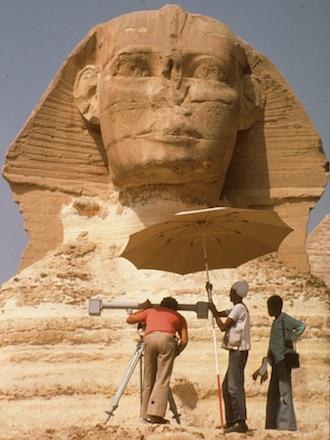
If Mark Lehner needed convincing that Egyptology could be dangerous, perhaps the realization arrived after he again scaled a rickety ladder, tiptoed along the ledge not even a foot wide, and, pencil in mouth, hands full of surveying tools, looked straight down from the side of the most famous statue on Earth. There, three stories below, on the best days, he would spot his trusted assistant, pacing and praying that Lehner would not fall.
Maybe Lehner was braver then, so many years ago. He certainly was smart enough to comprehend that history was being unlocked by those precarious ladder climbs, by the stone-clinging dance along that narrow ledge. He and his team were mapping this iconic statue in a way never done before or since.
Today, nearly four decades later, you might not begrudge Lehner time to think back to that perilous path, to those exciting years he devoted to circling, climbing and sizing up Horemakhet, The Guardian, The Terrifying One, Father of Dread. Because today is when all of those toils, to take the measure of The Great Sphinx of Giza, are being unveiled to the world. Finally, once and for all.
On January, 15 2018, an expanding digital version of the 1979-83 ARCE Sphinx Project was released, sharing for the first time the intricate maps, rough notes, precise measures and resulting revelations from Lehner and the rest of the ARCE team. The online release came 35 years after the end of the ARCE project and 4,500 years or so since the Great Sphinx was carved from the same bedrock used for the Giza pyramids.
The goal of the mapping was to understand the origin of the Sphinx from careful, recorded observations of its structure and geology. The idea was to read history from the condition of the man-lion’s core and its earliest masonry skins, from a 1:50 scale survey of this stratified narrative, and even from tool marks and mortar. If Lehner could learn what held the statue together and how it had been maintained over millennia, maybe we might understand more about how it was built, and by whom.
The 1979-83 project succeeded in hoped-for revelation and unexpected inspiration. The team certainly measured and recorded every historic layer and wrinkle of the icon. By mapping two nearby temples, the ARCE team exposed how builders likely made the Sphinx and the temples from a massive, quarry-construction landscape project. Yet Lehner and the 70 workers and experts he helped lead also would lay the groundwork for other repairs of the always deteriorating monument. And while Lehner would not know it at that moment, his work of so many years ago now offers a snapshot of archaeological and surveying methods of the time, when the meticulous synergy of human hands on ancient stone spawned their own unique emotions and mysteries.
But few learned of these accomplishments, then or later. For more than 35 years, the wonders and wondering of the work by Lehner and others have remained largely inaccessible to the public. For various reasons, Lehner’s 1991 Ph.D. dissertation at Yale – the documentary interpretation of what was found in 1979-83 – lay unpublished and available only in a substandard paper copy. And the maps, drawings, photos, notes and records behind that dissertation went the way of much of any history – into storage. In fact, the restorations and preservation of the Sphinx itself since Lehner’s journey up that ladder have now hidden much of what the ARCE Sphinx Project disclosed.
But no longer. A brand new American Research Center in Egypt Sphinx Project 1979-83 Archive, in searchable form, is now available. It is the world’s only online dataset to document the history of masonry work on the Sphinx prior to the contemporary efforts to save it for generations to come. The archive also offers yet another chapter in the storied narrative of a monumental lion with a human head, once buried, now unhidden and facing proudly east toward the eternal waters of the Nile.
THE LAYERS OF EGYPTOLOGY
The story of the mapping of the Sphinx and the release of those records after so many years is interlocked with the stratigraphy of Egyptology itself. Layers of exploration evolve over scores of generations, from pharaohs and peasants to professors and students, from restorers and measurers to photographers and digitizers. For this chapter, the layer belongs largely to Mark Lehner, the ledge crawler with the pencil in his mouth. Lehner is now the energetic, well-known president of the Ancient Egypt Research Associates (AERA), a multidisciplinary organization that focuses on the Giza plateau.
In 1978, before he became one of the world’s most recognizable Egyptologists, Lehner had just helped excavate the northeastern corner of the Sphinx sanctuary under the direction of Zahi Hawass, then chief inspector of the Giza Pyramids. Hawass and Lehner uncovered trenches in a mound of ancient deposits that explorer Selim Hassan had left when he excavated in 1937 and discovered a mudbrick temple of the 18th-dynasty King Amenhotep II on the ledge above the Sphinx floor. The deposits connected this New Kingdom temple, the northwest corner of the Old Kingdom Sphinx Temple and a small limestone stairway of the Roman period.
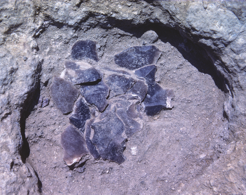
The lowest layers of the mound contained Sphinx builders’ pottery, flints and even faience beads, embedded in the debris of construction. Hawass and Lehner also found sockets cut into the bedrock floor to anchor thick wooden beams the size of railroad ties. These levers slid under multi-ton core blocks to maneuver them to the Sphinx Temple wall. As the two explorers cleaned the Sphinx floor with scrub brushes, they also discovered smaller round holes in the bedrock, many still filled with ancient deposits. And those holes were not just in the northeast corner, but here and there, and maybe everywhere, around the Sphinx.
The holes begat questions: Do they form patterns that would belie their purpose, such as supports for scaffolding so sculptors could shape the colossus? What would a map of them show? Indeed, Lehner knew the Sphinx itself had never been properly mapped the way archaeologists would today for any ancient feature. And wouldn’t a proper map of the shape, condition and stratigraphy of masonry skins added over millennia to the lion body tell as many stories as any papyrus text?
By 1979, Lehner had approached Paul Walker and James Allen, then the two leaders of ARCE, about his ideas. Together, they conceived the Sphinx Project. The goals: to produce the first-ever scale plans and elevations of the Sphinx itself and to map the greater Sphinx site, including three nearby temples and the larger quarry forming the greater Sphinx “amphitheater.”
With funding from The Edgar Cayce Foundation and with Allen (now the Wilbour Professor of Egyptology at Brown University) as principal investigator, the Egyptian government gave its permission. Lehner became field director, with he and Allen enlisting surveyors, archaeologists, geologists and other Egyptologists, not to mention staff, workers and others. Between 1979 and 1983, the team included: Ulrich Kapp, a photogrammetric surveyor from the German Archaeological Institute in Cairo; Egyptologist Christiane Zivie-Coche, then director of the Centre Wladimir Golenischeff, École Pratique des Hautes Études; surveyor Attila Vas; surveyor Susan Allen (now with the Museum of Fine Arts, Boston), archaeologist Peter Lacovara (then Museum of Fine Arts, Boston, now The Ancient Egyptian Heritage and Archaeology Fund); archaeologist and surveyor Cynthia Schartzer; geologist K. Lal Gauri of the University of Louisville and geologist Thomas Aigner, University of Tübingen. But first, more layers: The École Pratique des Hautes Études in Paris furnished the ARCE project with field notes, plans and 226 photographs compiled by Pierre Lacau from the excavations of the Sphinx directed by Emile Baraize between 1925 and 1936. When those historic documents were received in 1980, Lehner wrote: “The information they preserve will, we hope, make it possible for us eventually to produce, in effect, the archaeological report of the 1925-36 clearance fifty years after the fact.” (This is not to mention that many of the same Lacau and Baraize photos and records would join the online ARCE Sphinx Project Archive nearly 90 years “after the fact.”)
LIKE A LILLIPUTIAN ON GULLIVER: FROM PAW TO BULL’S EYE
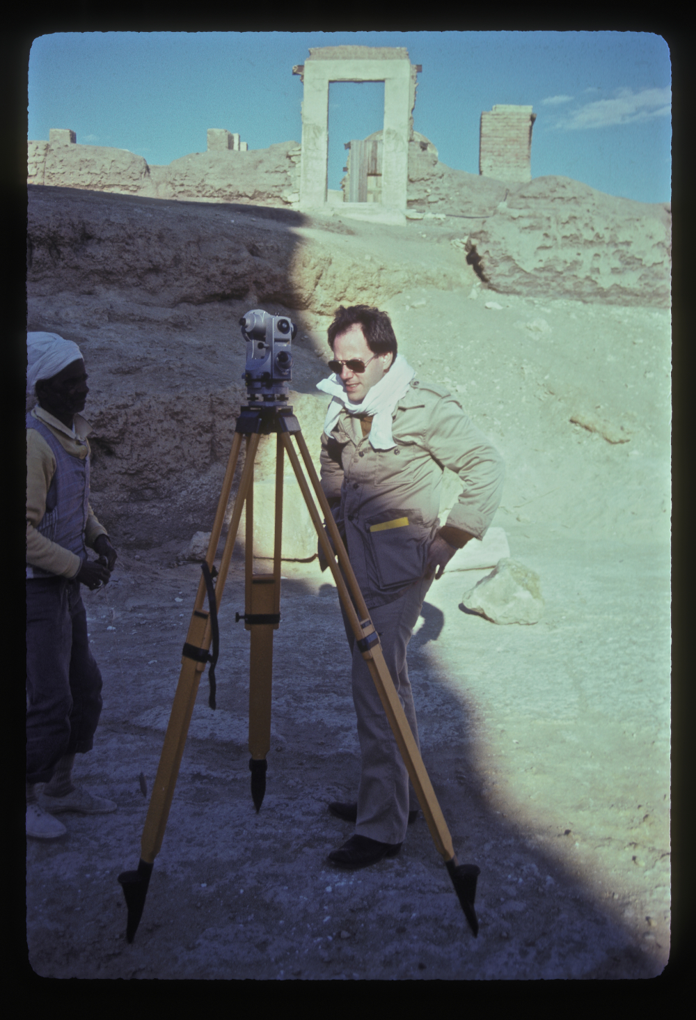
If you were to map an icon, where else would you begin than 3.64 meters (11.9 feet) in front of the right front toe of the right paw? That’s where Lehner and Matthew McCauley (now AERA board member) decided to anchor the grid for the ARCE Sphinx Project. Using an old transit with a built-in surveyor’s compass and brass Vernier scale, they oriented the grid to magnetic north on February 20, 1978. After selecting a cement marker 210 meters (689 feet) to the east of the Sphinx as an arbitrary datum for elevations, they transferred this vertical control to grid points marked in the floor around the Sphinx. The team then used these coordinate values and elevations in all the ARCE Sphinx Project records. After Lehner and surveyor Ulrich Kapp checked the grid with several theodolites (surveying instruments), the mapping could officially commence.
First, Kapp used a barbell-shaped, dual Jena-Optic stereo-metric camera to take photographs in stereo pairs. The camera was aimed toward carefully placed targets on the Sphinx – paper bull’s eyes stuck to the chest and sides or metered ranging rods set along the lion’s back. Toiling later in the basement of the German Institute in Cairo, Kapp was able to create front, north and south elevations of the Sphinx. They show the contours of the exposed parent-rock of the statue, plus the stonework attached to the core. At 1:50 scale, Kapp also produced master profiles through the statue every 5 meters (16.5 feet).
Lehner turned his attention to the corner where the mudbrick Amenhotep II Temple overlaps the Sphinx Temple – where he and Hawass had excavated the trenches and wondered about the holes that contained undisturbed ancient fill left behind from previous excavations. Lehner quartered the fill of each hole and excavated opposite quarters. These miniature excavations yielded artifacts such as flint flakes, chunks of chert and one quartzite hammer stone with copper flecks where a worker must have used it to strike a copper chisel. In one case the sherds joined to produce the wall of a vessel with a diameter and profile that matched that of the hole. The hole seems to have served as a socket for a crude red ware jar, which was later sheared off at the rim of the hole.
To complement Kapp’s photogrammetric elevations, the next job was the actual 1:50 master plan of the whole Sphinx. Without the benefit of today’s technologies and drones, Kapp could not get his large camera above the Sphinx for aerial views. So, Lehner and his team prepared for the arduous task of recording, in scale, the details of a statue three quarters of a football field long and more than 20 meters (66 feet) tall – a monument that had undergone a complex history of masonry additions.
The technique to be used was offset planning, also known as baseline offset survey, a common technique for scale line drawings of ancient surfaces. The process starts when an archaeologist stretches a metric measuring tape between two fixed points. With a drawing board in one hand and a folding rule or tape in another, the surveyor bends to grab an “offset” measurement from the stretched line to any point on a feature, say, the corner of a stone. In effect, mapping (or “planning,” as archaeologists say) by offset is taking the coordinate of any point, so the offset must be close to perpendicular and the measurement must be level. If the tape measure is stretched on the ground, at the same level as the features being mapped, archaeologists can take the offset directly. If the feature to be mapped lies in a lower plane, they must use a plumb bob and hold its point steady with a string. They then mark the point, to scale, on a drawing. To map complex, detailed surfaces, especially irregular surfaces – such as an ancient stone statue comprised of irregular pieces of various sizes – an archaeologist might take hundreds or thousands of measurements. With two people, one can measure while the other holds the plumb bob, or one can measure and the other marks the points. Instead, as Lehner remembers, most offset mapping of the Sphinx was solitary.
The work was a combination of exciting revelation and mundane drudgery. Lehner located the end points of his datum lines by triangulation from the grid points on the Sphinx floor. He sighted each point through a telescope on a theodolite and recorded the angle measurement from a grid line chosen as “zero.” (Later in the project, when team members obtained an electronic distance measurer they could locate points with one angle and a distance measurement.) The next step came when Lehner took a large sheet of clear mylar and used a protractor to draw the angles to each planning point from three or more grid points. The intersection of the angle lines located the planning point on the drawing, at 1:50. To match Kapp’s contouring of the bedrock core body in the front and side elevations of the Sphinx, Lehner produced a separate map of the contours on top of the back using a surveyor’s level.
Experienced offset mappers develop a rhythm, throwing their handheld tape or folding rule like fly-casting a fishing line, directly to a point at a good 90 degrees (best not more than a meter or two) from the datum tape. In this way, in a white hat to shade the Giza sun, Lehner and his team mapped, stone by stone, the broadest and near-level surfaces of the Sphinx: the top of the outstretched, masonry-covered forepaws and the top of the Sphinx’s back.
Lehner remembers the tedious process as meditative, involving both sides of the brain. The left brain’s realm of logic and language held the coordinate values, say 2.62 meters (8.6 feet) along the datum tape, .87 meters (2.85 feet) out on the offset. Meanwhile, the right brain’s realm of imagery held a feature’s shape, perhaps a trapezoidal stone. Left brain releases the coordinate values as they are marked on the scale drawing; right brain releases the image as the mapper connects the dots in the drawing, the outline of the trapezoidal stone complete.
Today, it’s all electronic and digital. Theodolites have electronic distance measurers, and surfaces can be scanned by laser. Photogrammetry has evolved into digital video or photographs, without the tedious task of hand-mapping by offset. These contemporary technologies are wondrous for urgency and efficiency. To Lehner, they also might represent how an archaeologist sacrifices an aesthetic rapport with data born from constant interaction between mind and hand, mortar and rock, sun and history.
MAPPING ON THE EDGE
When Emile Baraize excavated the Sphinx between 1925 and 1936, he found masonry skins of three ancient periods adhering to the bedrock lion. Baraize then added his own repair and masonry veneer, with more patchwork added in following years. Forty-three years later, Lehner started his mapping by identifying the ancient veneers as Phase I: New Kingdom, Phase II: likely Saite, Phase III: Greco-Roman. He also found that masonry covered the bedrock Sphinx “core body” to a little more than half the height on the south and about a third the height on the north. The entire bedrock front was exposed.
For Lehner, the masonry skins formed a convenient ledge of varying widths around the Sphinx core body. He and other team members could get close to the bedrock surface on the Sphinx’s northern flank by climbing onto the ledge from one of four mysterious boxes attached to the Sphinx. On the north flank, the casing stepped up and around the curve of the north haunch. From there, the skins angled down to a broader ledge at the lion’s rump and then up again around the southern rear haunch. Along the southern flank, the ledge was much higher than on the north and it thinned to 30 centimeters (11.8 inches) or less. There, three stories up, mapping still needed to be done.
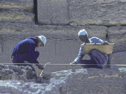
Imagine the steps: To get up there, you set the rickety, old ladder upon the southern masonry box. Clambering up with your gear and perhaps your fear, you carefully navigate the narrow ledge, drawing board in one hand, hand-tape or folding rule in the other, the mechanical pencil (with a .3 mm lead for finest detail, of course) protruding from your mouth. In installments, you cast your rod along the ledge, regardless of its narrowing width. More often than not, you bend to take the offset measurement with a plumb bob, which meant leaning the drawing board against the body of the Sphinx. And if you were Lehner and you were up there on that ledge, you most definitely could peer down to assistant Abd el-Gadar, nervously striding back and forth, praying.
After this challenging process, Lehner and team moved to the rest of the giant beast. Peter Lacovara mapped the wider and lower masonry ledge along the north flank. Cynthia Schartzer mapped the base outline of the statue. For the head, Lehner triangulated 63 points on the face and headdress from grid points on the floor. He wanted to know every contour, every blemish, every mark of time and history. The resulting plot was checked against “cuts” through the head and face from Kapp’s contoured photogrammetric elevations. Lehner used a similar procedure to plot over-hanging bedrock ledges down the sides of the Sphinx body.
THE STRATIGRAPHY OF A STATUE
Lehner distinguished the three ancient phases of the Sphinx veneers by the sizes of the slabs, mortar and tool marks. In some places he could separate the phases by patchwork, like a stonework quilt. In other places the layers overlapped. He could especially study this overlap along the masonry ledge where the “skin” had fallen away, leaving a cross-section through the history of Sphinx repair. To some extent, the monument’s deterioration became an opportunity to expose secrets buried by time. This was never as clear as in October 1981, when a patch of veneer from Phase III and the 1926 repairs collapsed from the north hind paw and spawned a six-year effort at repair and restoration. Lehner was able to map and photograph the exposed insides of the lion during those repairs. Later, after a chunk of Sphinx shoulder fell in February 1988, a new series of repairs was performed that were guided, in part, by the ARCE mapping.
Lehner was thus able to draw a series of detailed profiles and elevations at scale 1:20 to show that the bedrock core of the Sphinx had severely and differentially eroded. He found deep recesses along softer bedrock layers and rounded protrusions along the harder layers. Importantly, he determined that this deterioration seemed to have occurred before restorers added the most ancient and most extensive casing on the Sphinx with the largest stones, which Lehner designated Phase I. Lehner’s drawings capture places where boulder-sized chunks of the Sphinx were about to separate along thin, natural fissures before the Phase I casing fixed them in place.
Evidence suggests that Phase II, of smaller slabs that overlap and patch Phase I, may date to the 26th dynasty, and that Phase III, of smaller slabs nearly the size of bricks, is probably of the Roman period. Even then, a mere thousand or more years ago, this iconic statue still was of value and mystery to both royals and rabble. And worth saving.
But when was the Great Sphinx first rescued – when was Phase I? To help answer that question, Lehner focused on the masonry in what remained of a small chapel royal tucked between the forepaws. He knew this precious spot contained a time marker unlike any of the rest of the statue: The 3.5-meter (11.48 feet) tall, red granite “Dream Stela” of Thutmose IV has been precisely dated to Year One, Month Three of Inundation, Day Nineteen of his reign in the New Kingdom, 18th dynasty (1401 BCE).

With this knowledge, Lehner gave each structural element in the chapel a feature number and drew profiles to capture the structural relations between major parts. In one of many revelations from the ARCE project, he then proposed that workers for Thutmose IV must have dragged one of the granite lintels from Khafre’s nearby pyramid temple down to the Sphinx, set it up in the chapel and inscribed a royal narrative. The slab’s backside still shows the pivot sockets of a wooden door. From these clues and the stratified masonry, Lehner concluded that after workers delivered the Sphinx from the sand, birthing it (probably for the first time) as the god of an active cult under the name, Horemakhet (“Horus in the Horizon”), they erected Thutmose IV’s stela and added the chapel. Lehner even found material remains of the 18th dynasty chapel builders when he excavated blue pigment and pottery. The supposition was that this treasured debris included remnants of paint pots, quartzite tools and granite chips from etching the Thutmose IV stela with hieroglyphic text. That text is the story of how the Sphinx appeared as sun god to Prince Thutmose in a dream, asked for help and in effect ordained him as king.
But possible answers only lead to more questions. To what extent did the fourth-dynasty Egyptians complete the original sculpture in the natural limestone bedrock? Certainly, they of the fourth dynasty left the Sphinx Temple and the cutting of the Sphinx ditch incomplete. Indeed, Lehner and others cite available evidence to suggest the “ignition switch” for the Sphinx and its temple was never fully engaged in the Old Kingdom. Instead, the Sphinx itself was only “turned on” as a royal cult theme park more than a millennium later, during the New Kingdom, 18th dynasty.
BIG TEMPLES, GIANT BLOCKS, HUGE MAPS
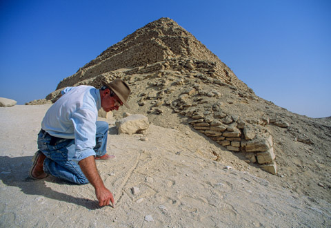
After he finished mapping the Sphinx at 1:50, Lehner went stone by stone to map at 1:100 the Sphinx Temple, directly in front of the lion’s outstretched paws, and the adjacent Khafre Valley Temple. Old Kingdom builders formed the walls of both temples on Terrace I, 2.5 meters (8.2 feet) lower than the floor around the Sphinx (Terrace II). The walls had been laid out with gigantic blocks of limestone, weighing up to 100 tons and quarried nearby. They were called “core blocks” because they formed the massive cores of the temple walls. Builders had intended to encase the walls in red granite, though they finished only the interior of the Sphinx Temple.
Amid these blocks, Lehner worked with geologists K. Lal Gauri and Thomas Aigner to identify the geological strata comprising the Sphinx. In the Sphinx Temple, they found that the geological layers often run continuously from one giant core block to another, just as the layers must have run in the bedrock. The conclusion: Crews of young men who moved these mighty stones did not have much chance of mixing them up from quarry to temple wall. Perhaps this meant the Sphinx and its temple had been part of the same quarry-construction sequence. To test this hypothesis, Aigner and Lehner logged each bedrock layer in the Sphinx core body and quarry. Aigner recorded the lithic qualities and fossil content and assigned each a number. He did the same for each block in the Sphinx Temple, and Lehner gave each block a number and assigned each to one of seven types, A through G, based on the quality of the stone and the kinds of embedded fossils.
The core block study prompted Lehner to re-map the temples in detail. He color coded the core blocks of the Sphinx Temple and Khafre Valley Temple and the bedrock strata of the Sphinx to identify the source layers for the building blocks. This remapping showed where the quarrymen were working at a given stage of building the temples. Together, the geology and temple mapping ultimately revealed a picture of how builders and quarrymen made the Sphinx and the two temples as part of a massive quarry-construction landscape project.
As if to match the colossal scale of the Sphinx itself, Lehner’s mapping was grand, too: Even at 1:100, half the scale of the master drawing of the Sphinx statue, the combined map of the Sphinx (front), Sphinx Temple, Khafre Valley Temple, plus a schematic plan of the Amenhotep II Temple, measures 1.23 by 1.83 meters (4 by 6 feet). These maps and plans added impressively to Lehner’s dissertation and to the many documents, notes, measurements and photos that supported it. With 67 plates, most of them Archive Lacau photographs, Lehner reconstructed in his Chapter 2 the massive, multi-year excavations through deposits and structures laid down around the Sphinx over three thousand years – making it a virtual archaeological tell. With 91 plates, Chapter 5 describes the bedrock statue, augmented in Chapter 6, with 40 plates, by a description of the masonry veneer. No wonder this massive document, with its trove of accompanying maps, plans and photos, would be hidden. Where could it all fit?
FROM BLUE BINDERS TO BYTES
The answer was to come many years later, in May 2016. That’s when Lehner’s AERA received an Antiquities Endowment Fund grant from ARCE. The goal, finally, was the conservation and online publication of the archive of the 1979-83 ARCE Sphinx Project, led by Allen and Lehner.
Over the last year and a half, Lehner and AERA team members have surveyed, organized, scanned, contextualized, described and preserved 364 maps and drawings; 3,857 slides; 1,740 black and white photographs and reports, journals and survey data, all compiled during the ARCE project. Partnering with Eric Kansa and Open Context—a web-based publishing service that archives archaeological research data for preservation and public access—the team created a dynamic, permanent online home for the Sphinx Project Archive.
Open Context would prove more ideal than paper copy for Lehner’s extra-large maps, as well as the master plans and elevations of the Sphinx. By way of the internet archive, the huge files of drawings and plans from the ARCE archive were loaded into the International Image Interoperability Framework server, which allows images to be sent to users’ browsers in manageable, smaller parts. In this way, viewers can browse the Sphinx and temple maps close up, homing in on details in large-scale drawings.
To reach that point, the digital archivists first had to translate the nomenclatures of Lehner’s fine-point pencils in 1980 to the digital bytes of 2018. During fieldwork, Lehner had designated broad areas such as Sphinx Temple, east of Sphinx Temple and Khafre Valley Temple. But he did not define formal boundaries, and his areas sometimes overlapped or subsumed smaller areas. For example, Lehner divided the Sphinx “Ditch” into various quadrants which were used to locate features, photos and drawings of the floor and statue. He also treated certain large structures as something between an area and a feature: the North Ledge, the Chapel, Rump Ledge, Rump Passage and the North Cliff. And Lehner designated the trenches excavated under Zahi Hawass in 1978 as “removals” (R1, R2, etc.), a term used for more excavations as part of the ARCE Sphinx Project. Finally, he designated particular configurations of masonry and deposits as “features,” with different types in mind. That meant, in Lehner’s language of discovery, Fa3 became “Feature, architecture, number 3.”
For the online archive, not only did Lehner and the rest of the AERA team need to translate terminology and define more precise boundaries, but they also had to transform the physical form of past research. In the 1980s, for example, Lehner kept all paper documents and drawings of a size A4 or smaller in blue binders, one for each area of the Sphinx Sanctuary (NE, SE, etc.) and one for “General.” He also organized black and white and color photos according to the areas within the Sphinx ditch and broader areas, while contending with the larger drawings on mylar, cut to various sizes. And, of course, Lehner kept field notebooks, diaries and a small notebook for survey data. Finally, he filled out forms for most black and white and color (slide) photographs, and for objects, samples and features. Lehner’s system, while functional during and after the ARCE fieldwork, needed to be freed of its inherent overlaps and ambiguities. With context as a goal, archivist Megan Flowers,
GIS Director Rebekah Miracle and Lehner created a spatial hierarchy; in other words, they translated blue binders into bytes. The archive team defined the limits of 89 contexts, sites, areas, sub-areas, removals and features, also calculating how these spatial entities nested within each other – a critical feature for the Open Context website.
While Miracle navigated the GIS realm of the data, Flowers and Lehner assembled the actual Sphinx-related materials. Unlike the never-moving mysteries of the Sphinx itself, the 1979-83 materials had endured several journeys in the nearly four decades since the mapping project. The archive had moved from Cairo to New York, Connecticut and Chicago until coming to rest in the AERA Boston office for the last 11 years. From there, the archive team sorted the hard copies so that technical assistant Stephen Dilks could scan smaller photos and field drawings, sort physical items by newly assigned file names and place it all in archival envelopes, folders and boxes. Meanwhile, the largest maps and drawings were sent for outside scanning, and Flowers assembled all high-resolution digital files for uploading to Open Context.
Much of the work was necessary drudge, namely filling out Excel spreadsheets with many thousands of cells. With Lehner’s input, the AERA team used the forms and notes from 1979-83 to fill in as many fields as possible. They then worked with Eric Kansa to transfer this data and metadata to the Open Context ARCE Sphinx Project 1979-83 website, with its own banner and home page. Today, the ARCE Sphinx Project Archive is available at arce.org/sphinx-project-archive. Mundane and necessary, painstaking and precise, this 21st-century labor became a monument to the numerical: The website shares a decades-old mapping of a millennia-ancient statue that has captivated immeasurable numbers of us over innumerable time. Egyptologists, archaeologists, historians, art scholars, educators and anyone can now view, use and interact with this dataset, whether the goal is to research or teach or whether the subject is archaeology and archaeological methods, the Sphinx itself and its surrounding temples, ancient building methods, the history of the excavation of the site or even the history of its restoration.
By digitizing and publishing these records of the Great Sphinx of Giza, ARCE aims to add to our knowledge of a salient marker of Egypt’s cultural heritage and its contribution to world art, even to humanity. The Sphinx Archive will continue to be fed and trained, to evolve as a unique context in archaeology and another reflection of our fascination with a collective past.
Compiled from reports by Megan Lallier Flowers, Eric Kansa, Mark Lehner and Rebekah Miracle